The opinions expressed in this commentary are solely those of the interviewee and do not necessarily reflect those of the National Council of Architectural Registration Boards (NCARB).
Scientists have warned that sea levels could rise by as much as six feet in New York City by 2100 due to climate change. Following the aftermath of Hurricane Sandy almost eight years ago, Regional Leader of Urban Design for HOK William Kenworthey, AIA, NCARB, began rethinking his approach to resilient design for coastal urban locations. Kenworthey, who led the consulting team for New York City Mayor Michael Bloomberg’s Special Initiative for Rebuilding and Resiliency, is still on a quest to find new solutions to address the framework for future projects located along coastal areas.
Why did you pursue a career in long-term resilient design for coastal cities?
I’m very interested in sustainable urban development and had the opportunity to work on many waterfront development projects across the country, so I think it was a natural overlap given my experience and interests. Specifically, I’ve worked on mitigating existing storm protections that have diminished neighborhoods—proposing resilient stormwater strategies, incorporating climate adaptation interventions in government policies, and designing for regular powerful storm events in sites throughout the country.
Can you tell us what you and your team are currently working on?
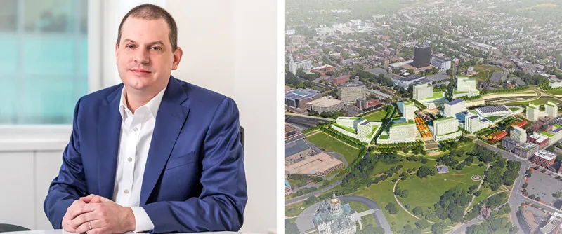
Our urban design and landscape architecture team is currently working on several confidential projects, from those on a district scale to more detailed public realm designs, as well as a master plan for the new LaGuardia Airport. We’ve also recently developed the Capital Gateway Plan— an infrastructure initiative set to transform mobility and access for surrounding neighborhoods through a new, transit-oriented development that bridges the I-84 highway corridor in Hartford, Connecticut.
Being based in New York City, can you tell us about some of your more recent design efforts to benefit the longevity of the tri-state area?
Mass transit plays a big role in producing a successful economy and urban development, especially in the tri-state area. Subways, trains, ferries, and airports are major assets that support New York City and its surrounding areas to operate as a dense, thriving metropolis. We recently partnered with the New York Building Congress on a project to reimagine Newark Liberty International Airport as an “airport city.” Our plan establishes a new and multifunctional transit hub over a regional rail station, creating an improved airport experience complete with airfields, terminals, AirTrain connections, and other developments, all raised above projected sea level rise. The concept supports transit-oriented development and would provide mixed-use economic opportunities, including housing and public spaces for surrounding communities.
How has becoming NCARB-certified enhanced your career path?
The NCARB Certificate has allowed me to obtain licensure in any jurisdiction when needed. I wouldn’t be able to practice nationally as easily without this certification. With NCARB’s robust Record-tracking tools, I’ve been able to easily manage my own professional history, the work history of architects in training who I oversee, and focus more time on leading our practice, plus winning new work. NCARB also provides great continuing education courses through the Continuum Education Program, as well as resources for licensure candidate and mentors.
Over the last five years, what has changed the most in your field, and what changes do you expect to see this decade?
Resilient design is not limited to addressing coastal flooding, but also encompasses all probable threats, hazards, and persistent problems a location may face. Recent major storm events have elevated the thinking around climate adaptation related to flooding, projected sea level rise, and even more powerful storms. I believe the current COVID-19 crisis will have a huge global impact on how we think about resilient design for major cities and other locations going forward. During conversations with colleagues, partners, and clients, we have started asking: How will this change interrelations within neighborhoods, cities, and regions? How will this impact international borders? How will people interact going forward? What is the value of urban density? This outbreak will be a much more existential challenge than coastal flooding. Cities are economic engines and they will need to adapt to these challenges to continue to thrive.
How are your recent projects incorporating resilient design in new and innovative ways?
We are actively working on design research for population migration within coastal cities given sea level rise projections. This is a very important topic as we won’t be able to protect everyone along the coast given the magnitude of impact to existing communities. In New York City alone, we have identified 7,200 acres of vacant land across the five boroughs, but not all of it is served by transit, and much of it will be in the future floodplain. Some questions we’re exploring include: Are these opportunities for development near existing or future transit? Who and what will the new coastline and floodplain impact? What opportunities are there for creating vibrant mixed-use density at higher elevations within the city? What are the potential economic development? How would we address the impacts of gentrification? Because cities are always evolving, testing scenarios and considering a broad range of long-term impacts are essential to understanding the choices we’ll have to make for the future.
How do you balance the day-to-day needs of a coastal community while providing resilient design measures to defend long-term threats?
The daily needs must be a part of the solution without precluding the future project, but many day-to-day stresses on a community end up being exacerbated during storm events. Many municipalities are considering phased approaches to projects, which allow for investing in the near-term with the ability to accommodate future modifications if worst case predictions become more likely. Flood mitigations need to add as much value to the public realm and real estate starting on day one, while providing protection during a storm. Solutions must have multiple benefits for a municipality and provide more than just an engineering marvel to become an interconnected part of city life, and ideally, economic development. For instance, a new flood barrier could also offer an elevated promenade along a waterfront and vibrant part of the city if it’s designed to connect and be an active place every day.
How has green infrastructure design practices for coastal communities evolved over the past five years?
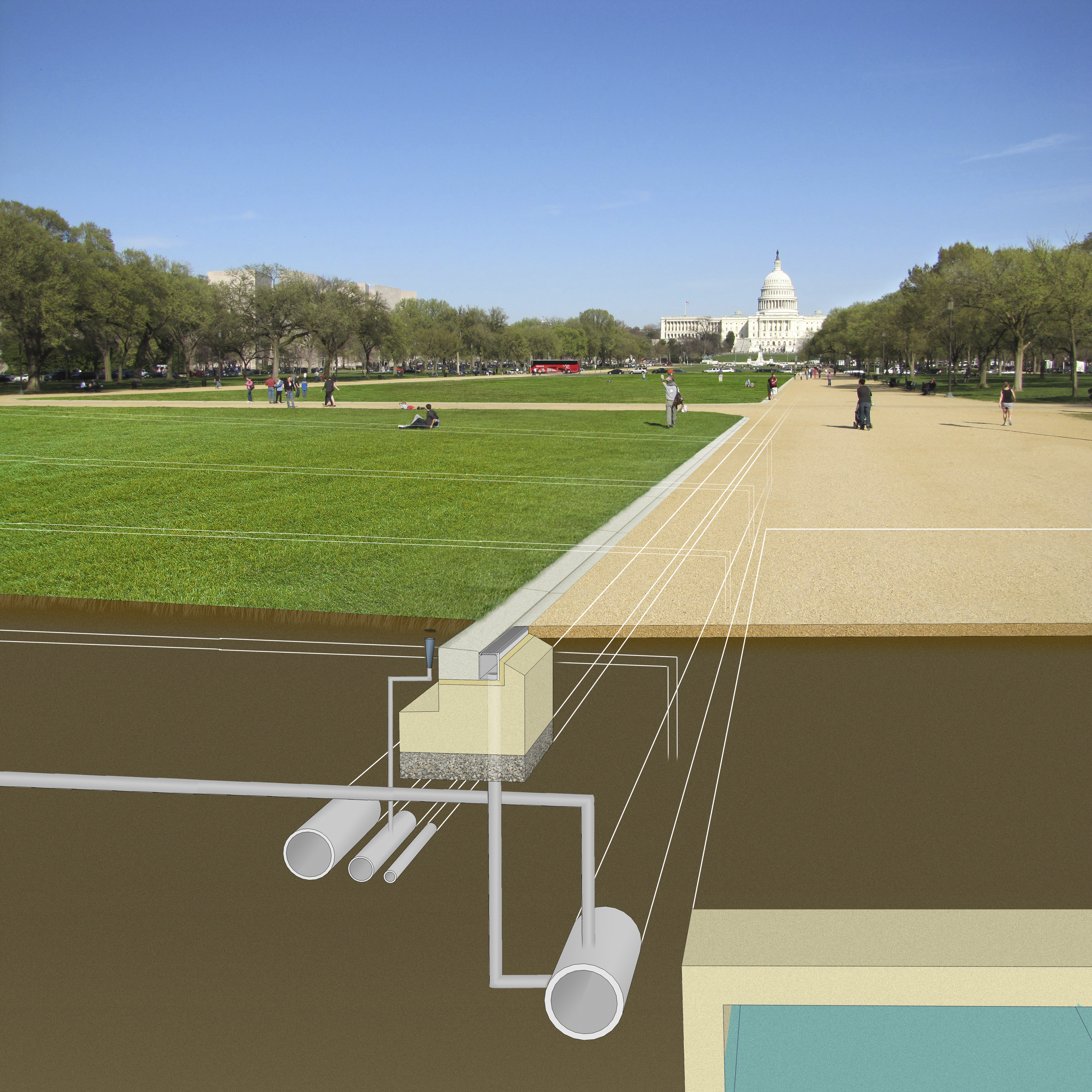
The environmental regulations are becoming the driver for many progressive stormwater strategies designed and implemented within states and municipalities. Our work on the renovation of the National Mall in Washington, DC, is a perfect example of this—featuring a one-million-gallon cistern to support water reuse for irrigation of the lawn.
When creating flood protections on the waterside, there often are concerns about flooding due to heavy rainfall on the landside. Using green infrastructure has helped address the quality of places on regular days, while allowing mitigation to effectively occur during storms. I worked on the master plan and public realm design for the Children’s Hospital of Philadelphia Roberts Center for Pediatric Research, which incorporates rain gardens near the street to absorb water from the site and surrounding district. Our initial design goal for the campus was to not let a single drop of water run-off into the river. All public spaces aspire to that goal with the use of topography and softscape design.
What advice do you have for future licensure candidates looking to pursue resilient design?
- Sustainability and resiliency are inseparable. They are integral to each other.
- Understanding data-backed and quantified performance of your design decisions is crucial.
- Be aware of the consensus of respected scientists and climate change projections.
- Vote! These issues require federal attention, investment, and coordination, as well as state and local efforts underway.
- It’s about design and strategy. Listen, but also aim to help your clients understand long-term value while addressing essential short-term needs.
- Be creative. Solutions can always be tailored around the place and people you’re serving.
Is there anything else you would like to share with our community?
Design is a hopeful, proactive process. Don’t be shy, but also make sure to listen. More importantly, have fun while you’re thinking about how to solve problems—it’ll make you a better designer in the long run and more “human.” Always remember you have a responsibility to help others learn how to live smarter on our planet. Too much is at stake to do anything less.
Based in HOK’s New York studio, William Kenworthey, AIA, NCARB, leads HOK’s planning and urban design projects across the Northeast. As an urban designer and registered architect, he has more than 20 years of experience working with government agencies, private developers, major universities, and Fortune 500 companies. Kenworthey has a particular interest in long-term resiliency of coastal cities and frequently presents at university and industry events about urban waterfront design. Early in his career, he also served as an associate urban designer for the Department of City Planning in New York City.